
about . rules . buttons . join . fans . update . home
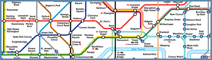
The Tube map is a schematic transit map of the lines, stations and services of London's public transit systems. The London Underground is the base of the map (which it is named after), but the map also includes the Docklands Light Railway and the London Overground network. In newer versions, the Emirates Air Line cable car and sometimes the London Tramlink are included.
As a schematic diagram, it does not show the geographic locations but rather the relative positions of the stations, lines, the stations' connective relations, and fare zones. The basic design concepts have been widely adopted for other network maps around the world, and for maps of other sorts of transport networks and even conceptual schematics.
The precursor for the current map was first designed by Harry Beck in 1931.
If you are looking for the standard map, you can find it here.
Sources: Wikipedia.org / TransportForLondon.gov.uk